


A lot of data available in Uzuverse and its platform. Credits: Ecole Polytechnique Federale de Lausanne
New approaches use aerial photography to generate highly accurate 3D models of cities and regions, enabling city planners to incorporate full-scale designs for all types of buildings and urban structures.
Two months ago, EPFL spin-off Uzufly moved to The Garage, a business incubator at EPFL Innovation Park where startups can grow and scale.A young company has created a virtual reality technology that enables city planner to formulate and communicate development plans;
Uzufly’s system uses drones aerial photograph, generate thousands of images that are transformed into 3D models through the creation of digital twins, or digital replicas of real-world objects. These objects could be, for example, buildings that are georeferenced to centimeters. The company’s 3D models incorporate a wide range of urban planning data and can be used at full scale for any type of building design.
Uzufly co-founder and CTO Theo Benazzi is leading the effort to create these highly accurate digital twins. “We’re basically using the same technology as Google Earth: aerial photography,” he says. “But Google takes a huge number of photos from airplanes, highlands, uses drones with smaller cameras to capture images closer to the ground. As such, you can generate 3D models at the neighborhood or city-wide level. ”
virtual workbench
Uzufly’s digital twins can be enriched with all kinds of georeferenced data such as land parcels, zoning areas, urban development structures, and underground infrastructure such as pipes. For example, you can add data from the Swiss Federal Terrain Service to display information about the solar capacity of individual roofs directly in your 3D modeling environment.
With all this data, Uzufly’s system is nothing less than a virtual workbench for urban planning. Architectural firms can install the system as part of their business software, download the areas commissioned to design a building, and begin the design process. There is no need to send a surveyor to get the layout of the land.
“City authorities used our system to determine how far an existing building could be expanded before hitting zoning limits,” said Romain Kirchhoff, co-founder and CEO of Uzufly. It also helped city planners figure out how a new building would fit in a particular area.Using our system, designers can do much better than planting stakes in the ground. You can get a feel for the space, which makes urban planning easier and improves decision-making.”
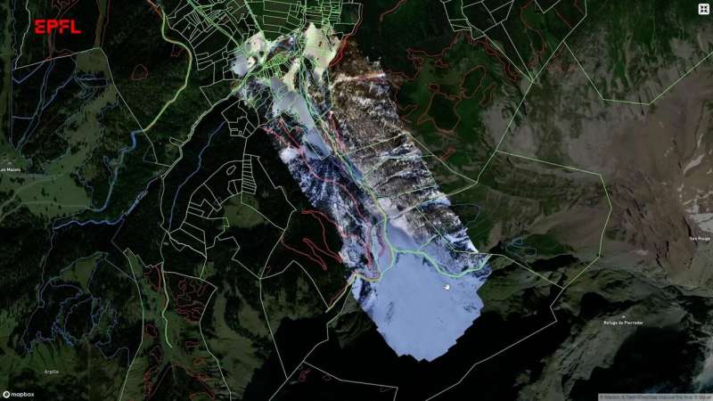
Avalanche map. Credits: Ecole Polytechnique Federale de Lausanne
Anne Bochard, Head of Urban Planning and Environment in Asnières, Geneva, was looking for an effective way to explain the school’s expansion plans to the local population during the hearing process. She also found blueprints hard to understand and wanted a more concrete method. Uzufly’s realistic 3D images fit that bill.
“Uzufly’s model has helped people understand our project more fully,” says Bosshard. “That was true for us because it helped us make important choices. I was able to see if it would affect the space in question and whether it would block the view of the Alps or the countryside.”
Video game developers are also interested in Uzufly’s technology. “A lot of our time in video game development now is modeling existing environments,” he says. “With our system, developers can, for example, create a version of Assassin’s Creed set here in Lausanne.”
Joint research and development with EPFL
Uzufly’s location is very close to EPFL’s main campus, which has allowed the company to set up joint R&D projects with several laboratories at the school. For example, working with an architecture student to improve his 3D model of a building, or working with the Institute of Geodetic Engineering (TOPO) to create a 3D model of a mountain slope based on thousands of photographs to create an avalanche model. are mapped.
Uzufly is also working on new projects in collaboration with EPFL’s Arts of Sciences Laboratory (LAPIS) and the Swiss National Science Foundation. By fall 2023, we plan to create a model of an Egyptian temple for archaeological and architectural research. Finally, we can incorporate augmented reality to help decipher the meaning of hieroglyphs.
provided by
Ecole Polytechnic Federal de Lausanne
Quote: ‘Google Earth on Steroids’ Boosts Urban Development (13 Dec 2022) Retrieved 13 Dec 2022
This document is subject to copyright. No part may be reproduced without written permission, except in fair trade for personal research or research purposes. Content is provided for informational purposes only.