NOAA
As its name suggests, the jet stream is essentially a river of air that moves at high speed through the atmosphere near the altitudes at which planes fly. They are typically hundreds of miles in diameter, and if jets can fly in this airflow, usually from west to east, they can certainly save a lot of fuel.
The jet stream also has a significant impact on surface weather, as it more or less guides storm systems that affect mid-latitudes. In other words, these influences largely determine whether regions of the United States, located almost entirely in mid-latitudes between the tropics and the poles of the Northern Hemisphere, experience severe or calm weather.
As always when it comes to weather, the situation is complicated. But one of the more useful signals for forecasters is the El Niño Southern Oscillation in the tropical Pacific Ocean. This oscillation causes sea surface temperatures to fluctuate between warmer temperatures (El Niño), cooler sea surface temperatures (La Niña), and neutral conditions. This widespread pattern affects a wide range of weather conditions, including the location of the jet stream.

NOAA/IRI
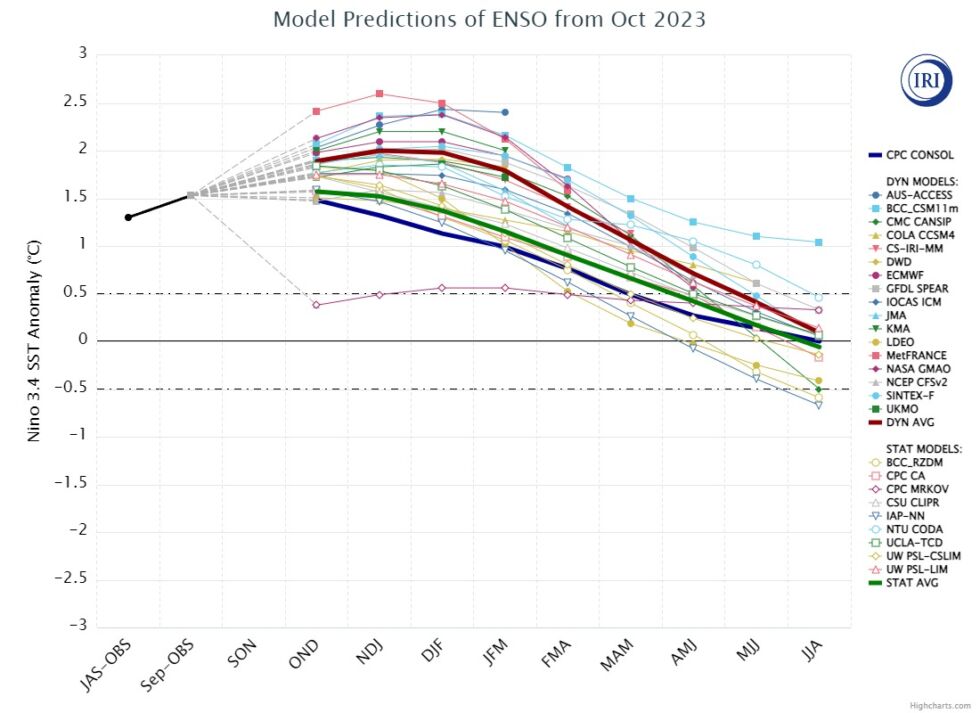
As you probably know, the El Niño phenomenon has been going on since late spring. This is one of the reasons why the summer of 2023 was incredibly hot, because after several years of La Niña, the occurrence of El Niño led to warming against the background of climate change. Forecasters at the National Oceanic and Atmospheric Administration and Columbia University, who specialize in the Southern Oscillation, now predict that El Niño will reach its peak later this fall and into winter. It will be a fairly strong El Niño event that will affect this winter and, more speculatively, next summer, which should be hot again.
winter outlook
When El Niño occurs during the winter, it typically has a noticeable effect on the Pacific jet stream. Rather than being variable in its path, often entering North America from near Washington state or southern British Columbia, it more consistently enters California and Mexico’s Baja Peninsula. This will push the storm’s path further south.
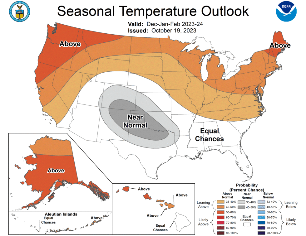
Because this pattern is what we are seeing this winter, we can have fairly high confidence in the seasonal forecast for the United States. So when NOAA released its official outlook for the upcoming winter last week, they predicted a warm and mild winter for the northern United States (and southern Canada, although not explicitly included in the U.S. agency’s forecast). No wonder he did. . The southern half of the country should see near-normal conditions.

NOAA
A more interesting change is in precipitation. Consistent with the more southern jet stream, the northern U.S. should have a fairly dry winter. This could likely mean less snow in the Great Lakes region of the country. However, storm patterns may strengthen in the southern part of the country, which generally means more precipitation.
This should benefit parts of New Mexico, Texas, Louisiana and Mississippi, which have been hit by “catastrophe.”abnormal drought“After a very hot summer with prevailing anticyclones and relatively little precipitation.
“Heavy rains in late October are likely to improve the drought in the central United States.” Said Brad Pugh, director of drought operations at NOAA’s Climate Prediction Center. “El Niño is expected to increase precipitation and reduce drought in the southern United States in the coming months.”
Overall picture
Of course, these are just rough background patterns. This doesn’t mean the upper Midwest won’t see snowstorms or deep cold this winter. You may remember that earlier in 2021, Texas experienced the coldest winter storm in half a century, leaving millions of people in the state without power. This extremely cold weather is thought to occur during the winter of La Niña, which brings milder weather to the southern United States. Therefore, as always, the usefulness of seasonal forecasts is relatively low.
The other wild card, of course, is climate change. This summer has seen unprecedented heat in many parts of the world, with parts of the Gulf of Mexico and the Atlantic Ocean experiencing record temperatures. We don’t really know what this means for old established weather patterns. All we really know is what George R.R. Martin told us decades ago: “Winter is coming.”


